
Where is the data for "The Army Route"?
I recently decided to start developping a website that will help cyclists to plan their long-distance trips on the EuroVelo network. In order to diminish the burden of the development, I first focus on the route I will ride this summer, namely The Pilgrims’ Route, EuroVelo route number  . As you can imagine, the cornerstone of such a project is data of good enough quality for the itinerary. In this post, I will illustrate the not-so-easy quest for geographical data.
The constraints.
- I cannot collect / create the track myself, since it would not be generalisable to the full EuroVelo network, unless I spend the next 5 years on the road and thousands of hours behind the computer. I can however marginnally edit the sources.
- By “geographical data”, I mean anything convertible to a polygonal line. Most of the time, this will be GPS data in the
GPXformat. - Even though this should be obviously their role, the EuroVelo network does not collect nor provide the data about the network. The task would have been otherwise very simple. When contacted, the EuroVelo chat officer passes off the responsability to the national authorities in charge of the network.
- In order to keep the post short enough, I will focus on Denmark only, but the same problem of multiple, non compatible sources are encountered in other countries, sometimes in an exarcebated way, like in Germany, where the many länder are each responsible locally for the bike infrastructure.
The quest - Part 1
Starting from the EuroVelo website we are first redirected to Cyclistic, an itinirary planner that does not seem to be working currently, and to haervej.com, the official Danish website for The Pilgrims’ Route. Indeed for some reason when entering Denmark, the Pilgrims’ Route suddenly changes its name for Hærvejen, “The Army Road”. Comprenne qui pourra!
Cyclistic has a page dedicated to Hærvejen but this is not helpful since the website is out of order. On its side, haervej.com points to the account of VisitViborg on GPSies, where we can download the track of The Pilgrims’ Route in three segments, in the formats GPX, KML or KMZ. Here is our first data source.
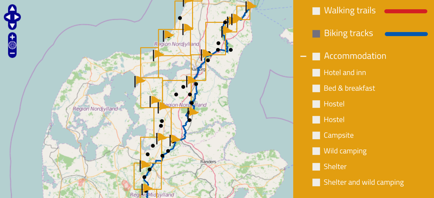
kort.haervej.dk is rich map, but not terribly user-friendly. Very rich indeed: only for accomodation, one has the choice between 8 possibilities, from the most luxuous (hotels) to the most rustic (shelters). The map, however, quickly disappears under a chaos of symbols.
haervej.com also points toward an interactive map, which unfortunately does not provide any information about sources. But an inspection of the page reveals that the cycle track in the KML format is served on demand by the following URL: http://kort.haervej.dk/index.php/en/?option=com_geocontent&task=layers.kml&typename=23. And here is a second data source.
Vejdirektoratet, the Danish agency for road maintenance, also provides a map of national cycle tracks, one of which is “Hærvejsruten”. When contacted about their sources, they reply that they rely on OpenStreetMapOpenStreetMap is an open-source equivalent to Google Map: the map is buildt collectively, and anyone can modify it. Click here for an introduction..
To finish with, Kortforsyningen, the Danish national agency for geographical information, surprisingly does not seem to provide any information about national (or local) cycle routes.
The quest - Part 2
I must confess that I discorvered the two last sources of data once I had stopped investigating the Danish case and on the contrary generalized my quest to the whole track of The Pilgrims’ Route accross Europe.
The first source is the already mentionned OpenStreetMap. The full route and the Danish section are independantly available. Compared to the other sources, OpenStreetMap has the advantage of being world-wide, constantly updated, vastly documented, and to potentially contain all the other EuroVelo routes. On the other hand, data consistency is the responsibility of each and every single mapper, and in pracice, the route can be interupted on some segments or, on the contrary, present competing itiniraries. Furthermore, downloading data from OpenStreetMap is not as easy as you may thinkIn this post, I explain how to export data from OpenStreetMap through the Overpass API. And discuss more in details the advantages and drawbacks of using OpenStreetMap.. OpenStreetMap counts as our third source.
Last but not least, I randomly encountered Biroto, a website explictily oriented towards multi-days bike trip – put in an other way: a competitor. Biroto collected and consolidated many different data sourcesFor Denmark, the source given by Biroto is a “hærvejsruten”. I then suppose it is the data from Vejdirektoratet. and then published the complete track of The Pilgrims’ Route as one unique file in GPX format. They are furthermore kind enough to distribute it under a CC BY-SA 3.0 licence. This is the fourth and last data source.
The results
The following interactive map displays the competing 4 sources. As we may have expected, the two sources extracted from haervej.com – the one from GPSies and the one from kort.harvej.dk – exactly coincide. The two others only marginally differ, like here in the center of Frederikshavn.